Following a Shared River Across National Boundaries
Following a shared river across national boundaries clarifies how neighbors discuss changing flows, exchange information, and balance competing water uses.
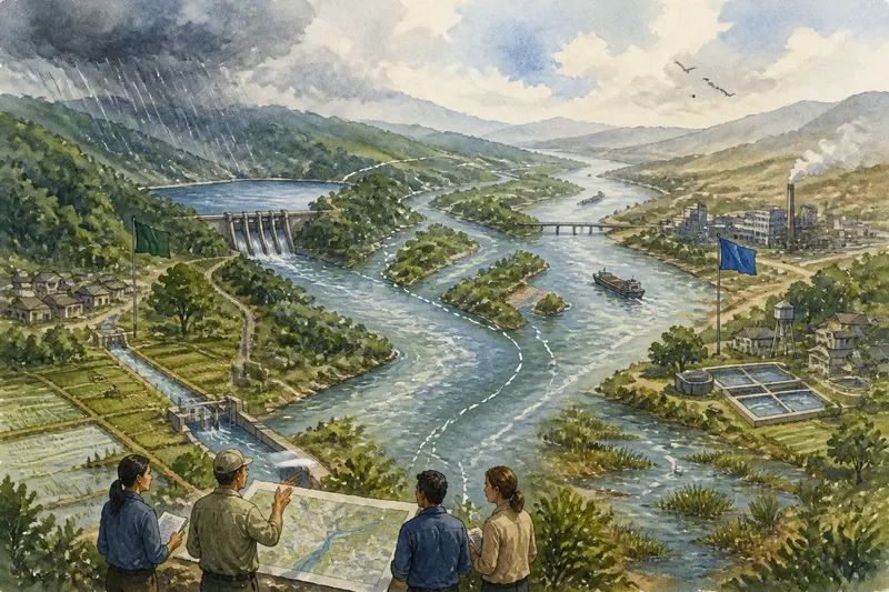
After rain in one country, a river may rise downstream in another before local officials there have seen the weather report. Following a shared river across national boundaries means tracing that connection through a river basin: the land where rain and streams drain toward a common river, lake, or outlet. The basin makes visible why neighboring countries need ways to discuss water flows, share information, and weigh competing uses.
What makes a river shared across borders?
A river is shared when its waters, tributaries, or basin cross a political boundary, or when actions on one side can affect water available on the other. The boundary may cross the main channel, follow it, or lie far from it while upstream streams still feed the same system.
This is why a map of the main river alone can give an incomplete picture. A dam, irrigation area, city, forest, or wetland in an upstream tributary may affect the timing or quality of water downstream. A basin map shows these connections more clearly by including the contributing land and waterways.
Countries do not necessarily share the same needs or authority. One may rely on a river for drinking water and farming; another may depend on it for navigation, hydropower, industry, or ecosystems. The river connects those interests, but decisions remain shaped by each country’s laws, institutions, and priorities.
Why can upstream decisions matter downstream?
Water moves through the basin, so choices affecting its quantity, timing, or condition may travel with it. A reservoir can store water and release it later. Irrigation can divert water before it reaches downstream communities. Wastewater or runoff can alter water quality, while land use may change how quickly rain reaches streams.
The effect depends on the river, the season, the location, and the choices made. A change may be small at one point but more consequential where several pressures meet. Nor does every upstream action create a clear or immediate downstream effect. Local weather, tributaries, storage, and other withdrawals can complicate what observers see.
These connections do not mean that one country can control the whole river or that all interests can be made identical. They do mean that a decision made within one jurisdiction may have consequences beyond it. A useful discussion starts by identifying the possible connection, then asks what information could clarify it.
What information do neighboring countries need to share?
Countries often need information about water levels and flows, reservoir operations, planned maintenance, withdrawals, water quality, and unusual conditions such as floods or drought. The useful information depends on the river and the decisions at stake. Data are most helpful when the parties can understand where they came from, how they were collected, and what they do not establish.
Shared monitoring can help make information comparable. For instance, agencies might agree on locations for gauges, common units, reporting intervals, and ways to flag missing or uncertain readings. A reading without its location, date, or collection method can be difficult to interpret alongside another country’s records.
Exchange can also include advance notice of planned activities that may affect another part of the basin. Notice gives the other side an opportunity to ask questions and explain concerns; it does not by itself settle whether the activity should proceed. Reliable communication channels matter too, since a routine report and an urgent warning call for different responses.
Transparency has limits. Some information may be incomplete, sensitive, or costly to collect. Those limits are easier to discuss when participants are clear about what is available, what remains uncertain, and who is responsible for filling gaps. Treating uncertainty as a reason to ask better questions is more useful than presenting a partial record as a complete account.
How do countries balance competing uses?
They need a process for discussing interests and trade-offs, because a shared river rarely serves just one purpose. A country may seek reliable water for households, while another emphasizes crops, electricity, shipping, or habitat. Within each country, communities and sectors can disagree as well.
Discussion can begin with the practical question: what problem is each proposed action meant to address? Participants can then consider timing, alternatives, who bears the effects, and whether those effects can be reduced or monitored. This helps distinguish a disagreement about evidence from one about priorities or the distribution of benefits and burdens.
Imagine two neighboring countries discussing an upstream reservoir. The upstream country says it needs storage to manage seasonal supply; downstream officials worry that releases may become harder to predict. They could exchange operating plans and flow records, clarify what each side means by a reliable release, and discuss how notice would work when operations change. The observable result would not be automatic agreement, but a more specific dispute that both sides can evaluate.
Public participation can widen the discussion beyond government agencies. Farmers, utilities, Indigenous peoples, local communities, environmental organizations, and businesses may hold relevant knowledge or face consequences. The way they take part varies by country and process, but naming affected groups helps officials see whose concerns are absent from a negotiation.
What kinds of arrangements support cooperation?
Countries may use treaties, commissions, technical working groups, informal communication channels, or combinations of these. A formal agreement can set out responsibilities and procedures; a commission may provide a continuing place to meet; technical groups can work through monitoring or water-quality questions. Informal contacts can help keep communication open, though they may depend heavily on the officials involved.
Arrangements differ in what they cover. Some focus on data exchange or warning systems, while others address planning, water quality, consultation, or dispute resolution. A document’s existence alone says little about whether participants share useful information or have a way to respond when circumstances change. The details of an arrangement and how countries apply it matter.
It is not worth expecting one agreement to settle every water dispute or remove every difference in power and interest. A more realistic purpose is to create dependable ways to raise concerns, clarify information, and continue discussions as conditions and needs shift.
What should a reader look for in a river-basin discussion?
Start by asking whether the conversation follows the basin or only the political border. Then look for whose observations are included, how information is compared, and whether the discussion identifies both uncertainty and competing uses. These questions help separate a useful account of shared water from a claim that treats the river as though it belonged to only one jurisdiction.
- Map: Does it show tributaries and the wider drainage basin, not just the border-crossing channel?
- Flow: Does the discussion distinguish water level, timing, quantity, and quality?
- Information: Are the source, location, and limits of shared data clear?
- Interests: Which uses and affected communities are named, and which may be missing?
- Process: Is there a defined way to exchange notice, raise concerns, and revisit a question?
- Uncertainty: Does the account explain what is not yet known instead of implying that one observation settles the issue?
Say a news report describes an upstream water project as a threat to downstream supply. A reader could check whether the report identifies the relevant tributaries, explains the expected effect on flow timing, and includes information from both sides. If those details are absent, the claim may still merit attention, but the available account does not yet explain the full connection.
Why does a basin view improve public debate?
A basin view replaces a simple upstream-versus-downstream story with a clearer account of how water and decisions connect. It gives readers a way to ask what is flowing, what information supports a claim, which uses may compete, and how neighboring governments can respond to one another.
Following a shared river across national boundaries does not require readers to settle technical questions on their own. It does help them notice when an argument leaves out the wider drainage area, treats uncertain data as decisive, or ignores people affected beyond a border. That attention makes public debate more precise—and makes it easier to judge whether a proposed arrangement gives neighbors a workable way to keep talking.